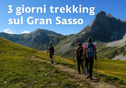
3-day trek on the Gran Sasso: the mountain huts loop
Gran Sasso d'Italia · 3 days · EE
The Gran Sasso huts loop
From Campo Imperatore to Prati di Tivo sleeping at altitude: three historic huts, the summit of Corno Grande and the crossing of the Sella dei Due Corni.
3 days3 hutsCorno Grande 2,912 mDifficulty EESummer
Day 1 — Campo Imperatore → Rifugio Duca degli Abruzzi
Time: about 1 hElevation: +260 mDifficulty: ENight: Duca degli Abruzzi
From the Campo Imperatore hostel (2,130 m) climb along the Monte Portella ridge to the hut (2,388 m). A short stage that leaves time to acclimatise and enjoy the sunset on Corno Grande.
Day 2 — Duca degli Abruzzi → Corno Grande → Rifugio Garibaldi
Time: 6–7 hElevation: about +700 / −850 mDifficulty: EENight: Garibaldi
From the hut descend to Sella di Monte Aquila and follow the normal route to the Western Summit of Corno Grande (2,912 m): rock and scree sections, views over the Calderone glacier. Return to the saddle and descend to Campo Pericoli and Rifugio Garibaldi (2,231 m). Garibaldi has no food service: if it is closed, go back to the Duca (1 hour).
Day 3 — Garibaldi → Sella dei Due Corni → Rifugio Franchetti → Prati di Tivo
Time: 4–5 hElevation: about +320 / −1,100 mDifficulty: EEFinish: Prati di Tivo (1,450 m)
From Campo Pericoli climb to Sella dei Due Corni (2,547 m), between Corno Grande and Corno Piccolo, and descend to Rifugio Franchetti (2,433 m) for lunch. The Vallone delle Cornacchie then leads to the Madonnina and Prati di Tivo (chairlift when open). Easy variant: from Garibaldi return to Campo Imperatore in about 1 hour.
Profile of the three stages
Day 1
Day 2
Day 3
Bars proportional to each day's ascent (green) and descent (orange).
Indicative times
Trails and times
Section
Time
Difficulty
Campo Imperatore → Rifugio Duca degli Abruzzi
about 1 h
E
Campo Imperatore → Rifugio Garibaldi (Sella di Monte Aquila)
45 min – 1 h
E
Sella di Monte Aquila → Corno Grande, Western Summit (normal route)
about 2 h 30
EE
Rifugio Garibaldi → Sella dei Due Corni → Rifugio Franchetti
about 2 h
EE
Rifugio Franchetti → Madonnina → Prati di Tivo
1 h 30 – 2 h
E
Rocca Calascio → Santo Stefano di Sessanio
about 1 h 30
T/E
One-way times for a fit hiker, in good weather and without snow.
If you have an extra day
Rocca Calascio and Santo Stefano di Sessanio
After the trek, about 40 minutes by car from Campo Imperatore, you reach Rocca Calascio (1,460 m), with the highest castle in Italy, and the medieval village of Santo Stefano di Sessanio (1,251 m). An easy trail of about 1 h 30 links the two villages.
Season: July–September, when the huts are open; check the weather and call the huts before leaving.
Equipment: boots, poles, warm and windproof layers, gloves, hat, head torch, water (no food service at Garibaldi), sleeping-bag liner or sleeping bag, offline map or GPS track.
Corno Grande: the normal route is EE, with rock sections; in fog, snow or storms give up the summit.
Phone coverage: patchy; save contacts and coordinates for offline use and tell someone your route.
Emergencies:112 or 118: mountain rescue is activated through these numbers.
Opening periods, contacts and services may change: always check with the hut before leaving. Data checked in October 2026.
Three days from hut to hut on the Gran Sasso d'Italia, in the Gran Sasso and Monti della Laga National Park: start from Campo Imperatore, sleep at Rifugio Duca degli Abruzzi and Rifugio Garibaldi, climb the Corno Grande and descend to Prati di Tivo via Rifugio Franchetti. It is a route for experienced hikers (EE): otherwise hire a mountain guide.
From Pietracamela to Prati di Tivo — Trekking and Ski Mountaineering
Dettagli
From Paganica to Pescomaggiore — Trekking, Mountain Biking and Ski Mountaineering
Dettagli
Madonna Fore — Trekking, Mountain Biking and Ski Mountaineering
Dettagli
The Ascent of Corno Grande
Dettagli
The Hundred Waterfalls (Cento Fonti)
Dettagli
From Fonte Vetica to the Base of Monte Camicia up to the Desiati Bivouac
Dettagli
From Castel del Monte to Campo Imperatore
Dettagli
Trekking and Mountaineering in the Montecristo Area — L'Aquila
Dettagli
Side sliding menu
Skiing in Abruzzo – snow report
The most popular ski resorts, the updated snow report and useful information on how to find lifts or book accommodation for your winter holiday
Dettagli
Webcams in Abruzzo
View the webcams in Abruzzo and check real‑time weather conditions. Some webcams belong to www.abruzzoparchi.it, others are located throughout the region
Dettagli
Abruzzo weather
Weather forecasts for the coming days in Abruzzo. Live weather via our webcams and temperatures recorded in several mountain areas
Dettagli
Abruzzo trail maps
Maps for trekking, mountain biking, ski touring, running and horse riding. You can also download the GPX track of each route
Dettagli
Abruzzo, Lazio and Molise National Park
One of Italy’s most famous and oldest national parks
Dettagli
Gran Sasso and Monti della Laga National Park
Dettagli
Velino‑Sirente Regional Park
Located in the heart of the Apennines, home to the beautiful villages of the Rocche Plateau
Dettagli
Majella National Park
One of the snowiest places in Italy, a unique mountain massif rising close to the sea
Dettagli
Experience Abruzzo
Abruzzo’s villages are famous for their fortresses, mountains and the traditional trabocchi along the southern coast
Dettagli
Holiday in Abruzzo
Choose between sea or mountains, summer or winter, a sporty holiday or a relaxing one — Abruzzo has it all
Dettagli
Traditional Abruzzese cuisine
Abruzzo is famous for its cuisine, both mountain and coastal, with traditions that vary from area to area
Dettagli
Outdoor activities
Walks, diving, climbing, mountain biking, horse riding — all outdoor activities available in Abruzzo
Dettagli
Three days from hut to hut on the Gran Sasso d'Italia: Duca degli Abruzzi, Garibaldi and Franchetti, with the Corno Grande ascent. Verified contacts, opening periods and times.
The most popular ski resorts, the updated snow report and useful information on how to find lifts or book accommodation for your winter holiday Vai
Webcams in Abruzzo
View the webcams in Abruzzo and check real‑time weather conditions. Some webcams belong to www.abruzzoparchi.it, others are located throughout the region Vai
Abruzzo weather
Weather forecasts for the coming days in Abruzzo. Live weather via our webcams and temperatures recorded in several mountain areas Vai
Abruzzo trail maps
Maps for trekking, mountain biking, ski touring, running and horse riding. You can also download the GPX track of each route Vai
Outdoor activities
Walks, diving, climbing, mountain biking, horse riding — all outdoor activities available in Abruzzo Vai
Holiday in Abruzzo
Choose between sea or mountains, summer or winter, a sporty holiday or a relaxing one — Abruzzo has it all Vai
Traditional Abruzzese cuisine
Abruzzo is famous for its cuisine, both mountain and coastal, with traditions that vary from area to area Vai
Experience Abruzzo
Abruzzo’s villages are famous for their fortresses, mountains and the traditional trabocchi along the southern coast Vai
Abruzzo, Lazio and Molise National Park
One of Italy’s most famous and oldest national parks Vai
Gran Sasso and Monti della Laga National Park
One of Italy’s wildest parks, with typical Apennine landscapes and Dolomite‑like peaks Vai
Velino‑Sirente Regional Park
Located in the heart of the Apennines, home to the beautiful villages of the Rocche Plateau Vai
Majella National Park
One of the snowiest places in Italy, a unique mountain massif rising close to the sea Vai